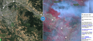
Robin Kraft, self-proclaimed “product/data guy with a thing for the environment,” has created a way for Northern California residents to safely check on their homes without being subjected to the dangers — smoke, debris, ash — that may be settled in their area. It’s also ideal for residents who have evacuated but don’t have the means to return quite yet.
Fire map update from TODAY 10/17! Smokey but too fresh to ignore. Sebastopol to Napa red=veg ????@DigitalGlobe???? @Mapboxhttps://t.co/RePO3yy2ND
— Robin Kraft (@robinkraft) October 18, 2017
Amid the destruction and sorrow caused by the wildfires, it seems a bit of positive news has surfaced: firefighters have been successful in containing 60 percent of the two largest fires, and weather reports indicate a chance of rain that could help extinguish additional flames.
This news may leave more residents anxious to return home — and many have already begun doing so. Fortunately, Kraft’s satellite fire map can show residents whether their neighborhood is safe enough to access.
 3 essential tools that will 10X your real estate marketing
Smart landing pages, a synchronized database and automation generate results READ MORE
To view the map, residents can visit Kraft’s website by clicking here, or simply search the map below.
Source: click here


